Type
The type defines the general purpose of the device.
—
Echo sounder. Echo sounders are devices designed to study water bodies using sonar. The principle of operation of an echo sounder is similar to that of a radar, but it does not use radio waves, but ultrasound. The initial purpose of such devices is the creation of topographic maps of the bottom of a reservoir, the determination of its topography and depth in various places. However, in addition to this, the echo sounder can be used to detect fish, and with good quality of the device and correctly set settings, you can even determine the approximate size of potential prey.
—
Chartplotter. A chartplotter can be described as a dedicated GPS navigator designed for marine use and equipped with related additional features. Such functions include, at a minimum, working with sailing directions (detailed maps of water bodies, indicating depths, currents, etc.); in addition, support for meteorological services, additional equipment such as radars or specific navigation sensors, etc. can be provided. Note that the GPS receiver can be either built-in or external; see Chartplotter Specifications for details.
—
Sonar chart plotter. Models that combine the capabilities of both types described above in one device. Such devices are the most versatile, however, and cost accordingly.
— Sonar fl
...asher. A specific type of echo sounder, designed specifically for use in one place, without movement. Initially, such devices were generally developed for fishing from an ice hole in winter — although this is not limited to such fishing — flashers are also used in summer, including in open water when fishing from a boat. Such devices are by definition capable of displaying fish in real time (see "Functions"), however, instead of a traditional screen, a circular indicator is used, thanks to which the user can determine the direction of the detected object. And the features of this object (more precisely, the signal reflected from it) can be determined by the colour of the mark on the indicator: for example, a red mark corresponds to a strong signal, yellow to an average signal, green to a weak one. Another advantage of a flasher over a traditional fish finder is its high sensitivity, which allows you to follow even small baits. Thanks to all this, such devices are quite popular among anglers, however, they are not cheap.Scan depth
the
maximum depth at which the sonar locator (see "Type") is able to operate effectively — in other words, how deep underwater the device is able to "see".
It is worth choosing an echo sounder according to this parameter, taking into account the actual depths at which it is planned to be used. Of course, this does not place a certain margin, but within reasonable limits (15-20%, less). For example, it hardly makes sense to specially take a model with a scanning depth of 200 m for a lake with pits of 30-40 m — such devices are expensive, while there will simply be nowhere to realize their full potential, and a powerful signal can also scare away the fish. But for marine or oceanic applications, a depth of a kilometer or more may be required; the most advanced echo sounders are quite capable of providing it.
Digital data processing
The presence of a
digital data processing system (DSP) in the design of the echo sounder.
Digital processing allows you to separate the received signal into extraneous noise and useful data. Of course, such a division is not 100% reliable; however, the level of noise in the filtered signal is still significantly reduced, and the screen receives a maximum of useful information and a minimum of extraneous information. The disadvantage of this function is traditional: echo sounders with DSP are somewhat more expensive than usual ones.
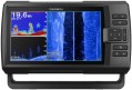
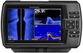
Display
— Screen size. Diagonal screen size in inches. The
larger the screen, the more information can be displayed on it and the more detailed this information can be. On the other hand, this parameter noticeably affects the dimensions of the device, and large screens are expensive, especially since you need the appropriate resolution for normal image quality (see below).
—
Touch. The presence of a sensor in the design of the display. This feature allows you to control the device by touching the icons on the screen — similar to how it is done in smartphones and tablets. Touch control provides more options than the classic one, using buttons and switches, besides it is more visual — however, such devices are more expensive.
— Display resolution. Display size in dots (pixels) horizontally and vertically. The higher the resolution, the more detailed image the screen is able to produce, the smaller objects can be clearly displayed on it and the more comfortable viewing. At the same time, the specificity of echo sounders is such that too high resolution is not required even for high-end models: for example, modest by the standards of smartphones or tablets 640x480 with a 5" screen are considered quite sufficient even for an advanced device.
— Colour. The ability of a screen to display colours. In this case, the simplest division is used:
Monochrome.... Displays that display information only in shades of one colour. Theoretically, the main colour can be any, but in this case, the vast majority of monochrome screens are black and white. Their advantages are low cost and energy consumption, as well as good visibility in the sun; at the same time, such an image allows you to work with quite a variety of types of data, which is enough even for very advanced echo sounders (see "Type"). However, this variety is not as wide as for colour displays, as a result, for chartplotters (see ibid.), such an image is not suitable — if it is impossible to display different colours, some of the important information on the maps is lost.
Coloured. Screens capable of working with multiple colours. The variety of colours can be quite small, but the image still turns out to be more informative than black and white: different colours can indicate different depths on the map, water temperature changes, etc. Due to this, this type of display is found in all types of navigation devices (see above). Its main disadvantage can be called a higher cost than that of monochrome screens.
— Backlight. The screen has its own backlight system. This feature makes the display independent of ambient light and allows you to see the information on it even in complete darkness. At the same time, the backlight increases power consumption, which is important during long-term operation from an autonomous source (for example, a boat battery). Therefore, it can be turned off.GPS module
The presence of a native
GPS satellite navigation module in a device with a chartplotter function (see “Type”). This module is responsible for determining the current geographic coordinates of the device and is thus a key element required for effective work with maps. At the same time, there are chartplotters that do not have this function — they are designed to connect an external GPS receiver.
Adding new maps
Ability to load new navigation charts into the chartplotter.
This possibility is extremely important in the light of two points. First, the base map (see above) rarely provides the level of detail needed to be used effectively — you have to download more detailed maps of individual areas. Secondly, it is very desirable to update even already loaded maps from time to time, since hydrographic information (depths, currents, shoals, fairway location, etc.) is constantly changing.