Application area
—
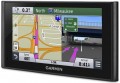
For passenger cars. Navigators designed for installation in passenger cars. As a rule, they are supposed to be installed on the windshield so that the screen is constantly in front of the driver’s eyes. Power is most often supplied through the cigarette lighter socket. Pre-installed cards, if any, are “tailored” for driving specifically in a passenger car - they contain data on the type and quality of roads, the characteristics of crossings and junctions, and other road factors.
—
For trucks. Devices for navigation and routing of trucks. Such models often take into account the design features of trucks, on the basis of which suitable routes are built, taking into account restrictions on weight, height, length, width and other factors. Also, navigators for cargo vehicles can take into account specific rules of different countries such as speed limits, travel time, etc.
—
For campers. Navigators for motorhomes, caravans and campers. Models of this type take into account specific features that may be important when traveling on a camper: length, dimensions, weight and other technical parameters of the “motorhome”. Maps in such navigators provide safe routes to travel, taking into account potential restrictions, contain information about camping parks, waste water disposal sites, gas stations, attractions, etc.
—
Motorcycles.... Motorcycle navigators are designed to be attached to the handlebars and, as a rule, have enhanced moisture and shock protection, allowing them to withstand the effects of atmospheric precipitation without consequences and withstand impacts and shocks when driving. In such models, screens measuring from 3 " diagonally are installed; power supply from 6 V or 12 V is often provided, which allows you to connect the navigator to the motorcycle’s on-board power supply and save battery power. The software part includes functions related to road traffic - the same ones found in navigators for cars (see the corresponding paragraph). Also, the Bluetooth function is very popular in motorcycle models (see “Interfaces”) - in this embodiment, it allows you to display voice prompts on a headset under the helmet or built into the helmet.
- Tourist. Tourist GPS navigators are designed primarily for hiking and are intended for tourism. The main set of cards for such devices are routes of various tourist destinations, attractions or hiking trails. Most of these models are initially intended to be carried in your pocket, like a smartphone or other similar gadget. They often provide a waterproof case and a good built-in battery for long battery life.
— Wrist. Wrist navigators are aimed at athletes and partly tourists. They are attached to the wrist using a special strap. The display of such models is predominantly monochrome, which is done to reduce energy consumption, and the set of cards is released with an emphasis on walking (or jogging). In addition to navigation tools, they can be equipped with functions for measuring heart rate and a fitness calculator.Pre-installed soft
The navigation programme, originally installed in the navigator and sold with it, in other words, a set of maps available to the user “out of the box”.
Most modern navigators are equipped with such programs (although the name of pre-installed maps is not indicated for all models). Note that the functionality of complete programs in different models may vary. Most often, these are the simplest maps of the world or the region in which this device is sold. However, there are exceptions: there are models with detailed maps, programs with advanced functionality, etc. Such exceptions are especially common among high-end specialized devices, in particular marine and aviation (see "Scope"). And for some navigators, there may be several options for pre-installed programs and even the ability to select such programs at the request of the user. All these details should be specified in each case according to the manufacturer or seller.
It is also worth considering that the characteristics often indicate only the general name of the cards. At the same time, the same card can be available in several versions that differ in functionality and, sometimes, terms of use (paid / free). However, the main features are basic capabilities, interface device, etc. — usually, are common to all versions. Therefore, by the name of the complete programme, usually, one can quite accurately determine the general capabilities and features of the card's functionality.
Lifetime map updates
Availability
of life-long updating of maps in this model of the navigator.
When buying a navigator with this feature, the user also acquires a subscription to map updates supplied in the kit. Such a subscription, in fact, is perpetual: updates are available all the time while the navigator is generally working. Thus, this service allows you to always have the latest maps at your disposal. It is found mainly in automotive and motorcycle models: it is for these areas of application that regular updates are most relevant, since traffic conditions can change very quickly. However note that the cost of subscribing to updates is included in the price of the device and affects it, sometimes quite noticeably.
Waypoints
The maximum number of waypoints that can be stored in the navigator.
A waypoint is a point on the map with specific coordinates set by the user. Such points can be used both to mark individual important places (work / home, regularly visited institutions in the city, camps or springs in nature, etc.), and when laying routes (it is convenient to designate intermediate points through which you must pass the route). The more points the navigator is able to "remember" — the wider its capabilities; in the most advanced models, this number can reach 10,000 or even more. On the other hand, extensive memory will also cost more.
Navigation functions (assistants)
Special navigation functions provided in the device.
—
Speed limit. A function that allows you to use the navigator to obtain information about the speed limit on a particular road. Most often, the speed limit is used in the operational prompt mode: the device warns the driver in advance about approaching a section of the road where the speed limit differs from the current one, and also issues a warning if the driver accelerates above the permissible limit. This can prevent not only an unpleasant conversation with the traffic police, but also a serious accident.
—
Traffic jams in real time. A function that allows the driver to see real-time traffic data on the device screen. As a rule, models with a traffic monitoring function provide detailed information about the volume of traffic in general. Moreover, this information is monitored and updated constantly, in real time, and is immediately taken into account by the navigator - to the point that if difficulties arise on a pre-planned route, the device can automatically reroute it to avoid congestion. At the same time, it is worth considering that real-time traffic data is usually transmitted through the TMC network (see “TMC receiver”), and it is not available everywhere.
—
GPS informant. A function to provide the driver with various useful information related to the current location. In acc
...ordance with the name, the coordinates are determined using GPS. One of the most common ways to use an informant is to warn about approaching traffic cameras, stationary traffic police posts and speed control systems. In addition, other functions may be provided - for example, informing about entering a section of the road with a high accident rate or a separate large hole on the roadway. To operate the GPS informer, a database of relevant objects is entered into the device’s memory. When purchasing a navigator, it doesn’t hurt to clarify what exactly this database contains, how recent it is, and whether it can be updated.
— Lane selection. A function that provides the driver with hints regarding lane selection. Such tips make driving more convenient and safe: the navigator warns the driver in advance about the need to change lanes for a turn/turn (or vice versa, in order to drive straight past the turn). This allows you to avoid “misses” on the road and emergency lane changes, which often create emergency situations. This function is especially relevant for complex interchanges on multi-lane highways.
— Parking in real time. As its name suggests, this feature allows you to determine if there are nearby parking options for your vehicle. In addition, navigators that support the real-time parking function are also capable of displaying various auxiliary information, for example, type of parking, parking cost, payment methods, etc.
— The way back. The function of using a record of the distance traveled as a route to return from the finish point to the start point. Thanks to it, the customer can go back the same way he got to the current point. This opportunity is especially important in conditions of difficult terrain and the absence of roads - for example, during hiking trips or off-road jeep trips: returning along an already explored path is often easier and safer than looking for a new route. Actually, the opposite way is found mainly among universal pocket navigators (see “Scope of Application”), although there are exceptions - for example, the same car models.
- “Where am I?”. A function that helps the customer determine their current location. At the same time, we are talking not only about a point on the map and geographic coordinates - in addition to this data, the navigator, when you turn on the “Where am I?” function. displays various additional information: the address of the nearest building, information about the nearest intersection, nearby important objects (gas stations, hospitals, police stations, etc.).
— Prices at gas stations in real time. A function that provides information about current fuel prices at various gas stations along your travel route. It can be useful for drivers, as it allows them to find the most profitable or nearest gas stations to refuel and save money.
— Weather in real time. A feature that allows the navigator to receive real-time weather data. This can be either information about current weather conditions in a particular place on the map, or a forecast for a certain period. In addition to basic weather information (temperature, fit, wind, humidity, fog, etc.), this service can support advanced data such as storm warnings, flood or landslide reports. The necessary data can arrive in different ways - most often through a satellite or a special radio channel. These details should be clarified separately.
- Supervision of children. A function that allows the driver to use the navigator screen to observe the rear seat of the car without turning around and without being distracted from the road. Most often it is used to monitor a child who is in the back seat. Of course, to use the child monitoring function you will need not only a navigator, but also a camera compatible with it.TMC receiver
The presence
of a TMC receiver in the design of the navigator.
TMC (Traffic Message Channel) is a technology for transmitting information about adverse traffic situations — traffic jams, accidents, weather conditions, etc. Transmissions are most often carried out in the FM band, similar to conventional radio broadcasting; therefore, you do not need to access the Internet to obtain important traffic information, although some TMC services may be chargeable.
It is worth bearing in mind that a network of appropriate stations is required to use TMC. Such networks exist in many European countries, but their development in the post-Soviet space began relatively recently. Therefore, before buying a navigator with this function, you need to check whether TMC coverage is available in your area.
Display
Parameters of the display installed in the navigator.
— Display diagonal. Size screen size in inches. The larger the screen, the more information can be displayed on it and the more detailed this information will be presented. On the other hand, the size of the display significantly affects the dimensions of the device, and large screens are more expensive.
— Display resolution. Display size in dots (pixels) horizontally and vertically. The higher the resolution (with the same diagonal), the more detailed and clear the image the screen can produce. In addition, on high-resolution displays, small details are better visible, which increases the comfort of viewing information. Too high a resolution is usually not required for GPS navigator displays: for example, 800x480 pixels, limited by the standards of smartphones or tablets, with a diagonal screen size of about 6” are considered quite sufficient even for an advanced device.
— Matrix type. This parameter is indicated mainly for tech cases when the screen uses a high-quality
IPS type matrix. This technology provides high quality color rendering, good brightness and wide viewing angles; moreover, IPS screens are relatively inexpensive to produce.
- Touch. Screen support for touch control. You can give commands to the device by touching the icons on the display itself - similar to how this is done in smartphones and tablets. Touch control opens up
...many more possibilities than classic controls and provides flexibility in working with the navigator. In particular, by touching the screen you can set points on the route, zoom in or out on the map, etc.
- Color. This parameter determines whether the screen is color or monochrome (black and white). Black and white displays are simple, inexpensive, consume little power, and are quite suitable for displaying basic navigation information. At the same time, color screens are more functional: maps often use different colors to highlight individual objects, which would not be possible on monochrome displays. As a result, black and white screens are quite rare among modern navigators - mainly among the most compact and inexpensive models.
— Backlight. The screen has its own backlight system. This function makes the device independent of external lighting: the illuminated image will be normally visible both at dusk and even in complete darkness. It is also worth noting that many LCD screens have a backlight by default; it is activated when the screen itself is turned on and works regardless of external lighting - without it, the image on the matrix would simply be impossible to see. In particular, this operating principle is used in IPS-type matrices, which have gained popularity in modern portable electronics (including navigators).Field of view
Viewing angle of the built-in video recorder installed in the navigator.
The size of the space covered by the camera directly depends on the viewing angle: the wider the angle, the larger the size of the area that enters the frame, and the less likely it is to miss an object or event located on the periphery of the frame. On the other hand, ceteris paribus, an increase in the viewing angle gives the effect of reducing the picture — individual details look smaller and are less clearly visible. And at too wide angles, noticeable distortions appear on the edges of the image.
Speaking about the specific values of the angles, it is worth noting that the minimum indicator found among the registrars is about 50 ° — this is comparable to the field of view and the degree of magnification of the human eye (excluding side vision). The maximum viewing angle can theoretically reach 180°, however, in fact, navigators use cameras with more modest characteristics — mainly up to 120°.
More features
—
GSM/GPRS module. Built-in wireless cellular module, similar to those found in GSM mobile phones. However, unlike phones, in GPS navigators this communication is intended solely for Internet access. Most often it is used to obtain information about traffic jams, although some advanced models may provide the ability to fully view Internet pages through the built-in browser. To use the GSM/GPRS module, as in the case of a mobile phone, you need to purchase a SIM card from a mobile operator.
—
Digital camera. The navigator has its own digital camera; in some models there may even be two such cameras, on both sides of the body. The specific functionality of a digital camera(s) may vary depending on the capabilities of the device itself. Thus, most models with a DVR function use a built-in camera (for more details, see “Built-in DVR”). If you have a telephone module (see the corresponding paragraph), the camera can be useful for video communication. Many navigators with this function can also be used for classic photo/video shooting; The image quality, however, is usually relatively low.
—
Video player. Ability to use the navigator to play video files. As a rule, we are talking about playing video on your own display - accordingly, the display itself is made in color and quite large for this purpose. This function is found mainly among car navigators (see “Sc
...ope”), it is especially appreciated by drivers who have to spend a lot of time waiting - in particular, taxi drivers and truck drivers.
- Voice control. The ability to control the navigator using voice commands. This feature is especially convenient for automobile and motorcycle devices: it allows you to control the device without taking your hands off the controls and without taking your eyes off the road. However, before purchasing such a model, it would not hurt to clarify which languages it supports for voice control.
— Playback images. Ability to use the navigator screen to view graphic files; By default, JPG support is implied; other graphic formats are somewhat less common. A navigator with this function can be used as a digital photo frame - connect an external storage device and view pictures directly, without the participation of a computer. This function can be useful, for example, for viewing photos taken during a trip (when you don’t want to wait to get back to the computer), or for more specific purposes - for example, clarifying navigation data from a scan of a paper map.
— MP3 player. The ability to play audio files with the navigator (most often in MP3 format, hence the name). Playback can occur through headphones or an external audio system (if it is possible to connect them) or through the navigator’s own speaker. Such files can be stored in the device’s own flash memory or on removable memory cards.
— FM transmitter. Low-power FM transmitter with an effective range of several meters. It is one of the simplest ways to connect a navigator to a car's speaker system - just tune the FM receiver of the car radio to the frequency of the transmitter. In this way, you can use the car speakers, for example, to play voice prompts, music (see MP3 player) or the soundtrack of a movie being played (see Video player).
— Barometer. An auxiliary function that allows you to measure atmospheric pressure. It is often used as an additional tool in navigators with the function of measuring altitude using signals from satellites - this ensures increased accuracy of the received data. In addition, data from the barometer can be useful in forecasting the weather for the near future: for example, a sharp drop in pressure usually means worsening weather - even a storm or even a hurricane.