
Comparison Amazfit Bip 3 Pro vs Amazfit Bip 3
Add to comparison | 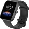 | 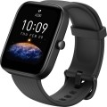 |
|---|---|---|
| Amazfit Bip 3 Pro | Amazfit Bip 3 | |
| Compare prices 6 | Compare prices 4 | |
| User reviews | ||
| TOP sellers | ||
It differs from the regular version by the presence of a GPS module and support for swimming mode. | ||
| Type | smartwatch | smartwatch |
| Interface | Bluetooth v5.0 | Bluetooth v5.0 |
Telephony | ||
| Calls and alerts | notifications vibration | notifications vibration |
Sports and tourism | ||
| Possible measurements | heart rate monitor blood oxygen level number of steps distance traveled calories burned activity time sleep tracking stress level women's calendar | heart rate monitor blood oxygen level number of steps distance traveled calories burned activity time sleep tracking stress level women's calendar |
| Sports modes | 61 | 60 |
| Swimming mode |  |  |
| Navigation | GPS module | |
Display | ||
| Touch screen | | |
| Type | colour | colour |
| Display type | TFT | TFT |
| Size | 1.69 " | 1.69 " |
| Screen resolution | 280x240 px | 280x240 px |
| PPI | 218 ppi | 218 ppi |
| Watch face protection | glass | glass |
| Bezel-less | | |
Hardware | ||
| Extra features | accelerometer | accelerometer |
Power source | ||
| Device charging | magnetic | magnetic |
| Source of power | Li-Ion | Li-Ion |
| Battery capacity | 280 mAh | 280 mAh |
| Operating time (normal mode) | 14 days | 14 days |
| Battery life (GPS) | 168 h | |
Case and strap | ||
| Material | plastic | plastic |
| Strap | quick release | quick release |
| Strap Options | rubber/silicone | rubber/silicone |
| Clasp options | classic buckle | classic buckle |
| Band Width | 20 mm | 20 mm |
| Wrist strap | 153 – 218 mm | 153 – 218 mm |
General | ||
| Protection rating | 50 WR (5 ATM) | 50 WR (5 ATM) |
| Dimensions (without strap) | 44.1x36.5x9.65 mm | 44.1x36.5x9.65 mm |
| Weight | 33 g | 33 g |
| Color | ||
| Added to E-Catalog | august 2022 | august 2022 |

Compare Amazfit Bip 3 Pro and Bip 3
Price comparison
You may be interested in
Amazfit Bip 3 Pro often compared


Amazfit Bip 3 often compared


Glossary
Sports modes
The number of types of sports training supported by the smartwatch. The more of them, the wider the coverage of the potential audience is provided by a wearable gadget on the wrist.
The most common sports modes include running, walking, cycling, swimming, elliptical exercise, and so on. The quantity and quality of data for different sports depends on the technical level of equipment of a particular device. While some models only record heart rate and roughly calculate the number of calories burned, other smartwatches evaluate the effectiveness of a workout using a detailed list of data and even draw a conditional run track based on information from GPS satellites.
The most common sports modes include running, walking, cycling, swimming, elliptical exercise, and so on. The quantity and quality of data for different sports depends on the technical level of equipment of a particular device. While some models only record heart rate and roughly calculate the number of calories burned, other smartwatches evaluate the effectiveness of a workout using a detailed list of data and even draw a conditional run track based on information from GPS satellites.
Swimming mode
A training programme for waterproof smartwatches or fitness trackers with water sports disciplines support. In swimming mode the wearable gadget determines the speed, distance and time of the swim, advanced instances of smartwatches measure the number of laps in the pool, calculate the frequency and efficiency of strokes in certain swimming styles. A personal assistant on the wrist evaluates the performance of water workouts and often makes recommendations to improve their effectiveness.
Navigation
This block contains both various navigation systems ( GPS, Galileo) and auxiliary features for them ( aGPS, GPS tracking, maps, compass, altimeter , barometer). More about them:
— GPS module. GPS satellite navigation module built right into the watch/tracker. The initial purpose of such a module is to determine the current geographic coordinates; but how this information will be used depends on the specific type and model of the gadget. For example, in some devices GPS is used only for measuring the distance traveled and/or speed of movement, while more advanced models support full navigation and are equipped with built-in maps. In addition, this feature is almost mandatory in children's beacons (see "Type") — it is GPS that is responsible for determining the location of the child.
— aGPS. An auxiliary feature that allows you to speed up the start of the main GPS receiver. To work for its main purpose, such a receiver must update data on the location of navigation satellites; Obtaining this data in the classical way, directly from the satellites themselves, can take quite a long time (up to several minutes). This is especially true for the so-called "cold start" — when the receiver starts up after a long break in opera...tion, and the data stored in it has become completely outdated. aGPS (Assisted GPS) allows you to receive up-to-date service information from a mobile operator — from the nearest base station (this feature is supported by most operators nowadays). This can greatly speed up the startup process.
— GLONASS. This system is a Russian alternative to the American GPS. However it provides somewhat less accuracy, so GLONASS support is usually provided in addition to the GPS module. Simultaneous use of two systems, in turn, improves positioning accuracy.
— Galileo. European satellite navigation system, created as an alternative to the American GPS. Note that it is under the control of civilian departments, not the military. With a full fleet of 24 active satellites, the system gives an accuracy of up to 1 m in public mode and up to 20 cm with the GHA service. Working in conjunction with GPS, the Galileo system provides a more accurate position measurement, especially in densely populated areas.
— Maps. The feature of displaying topographic maps of the area with heights, relief and types of vegetation on the clock screen. Preinstalled maps are used for visual GPS navigation without being tied to a smartphone. Often, the ability to display maps is implemented in tactical smartwatches with a focus on tourism.
— GPS tracking. Many watches with the possibility of laying routes have the feature of guiding by the GPS track. At the same time, the wearable gadget acts as a navigator around the area, showing the route on the screen and suggesting where it is necessary to turn in one direction or another. Some smartwatches with a pronounced touristic bias also have a “Return Route” programme that allows you to go back along an already traveled route. In GPS tracker mode, trackpoints are usually recorded automatically based on the selected fixing interval. You can also mark a track point manually at any time.
— Compass. A classic compass is a device that indicates the direction to the cardinal points. Wearable gadgets usually use an electronic compass — a miniature magnetic sensor, the data from which, if necessary, are displayed on the display.
— Altimeter. A feature that allows you to determine the current altitude of the user's location. Note that the principle and format of the altimeter may be different. So, some models use barometer data for height measurements, others use information from a GPS sensor; the height itself can be determined relative to sea level, relative to some reference point, or in any of these ways, at the choice of the user. These details should be clarified separately.
— Barometer. A feature that allows you to determine the current atmospheric pressure. One of the applications of the barometer is weather forecasting: for example, a sharp drop in pressure usually signals the approach of bad weather. In addition, information from this sensor can be used to operate the altimeter (see above); and even if the gadget does not have an altimeter, the height difference between two points on the ground can be easily calculated from the pressure difference between them.
— GPS module. GPS satellite navigation module built right into the watch/tracker. The initial purpose of such a module is to determine the current geographic coordinates; but how this information will be used depends on the specific type and model of the gadget. For example, in some devices GPS is used only for measuring the distance traveled and/or speed of movement, while more advanced models support full navigation and are equipped with built-in maps. In addition, this feature is almost mandatory in children's beacons (see "Type") — it is GPS that is responsible for determining the location of the child.
— aGPS. An auxiliary feature that allows you to speed up the start of the main GPS receiver. To work for its main purpose, such a receiver must update data on the location of navigation satellites; Obtaining this data in the classical way, directly from the satellites themselves, can take quite a long time (up to several minutes). This is especially true for the so-called "cold start" — when the receiver starts up after a long break in opera...tion, and the data stored in it has become completely outdated. aGPS (Assisted GPS) allows you to receive up-to-date service information from a mobile operator — from the nearest base station (this feature is supported by most operators nowadays). This can greatly speed up the startup process.
— GLONASS. This system is a Russian alternative to the American GPS. However it provides somewhat less accuracy, so GLONASS support is usually provided in addition to the GPS module. Simultaneous use of two systems, in turn, improves positioning accuracy.
— Galileo. European satellite navigation system, created as an alternative to the American GPS. Note that it is under the control of civilian departments, not the military. With a full fleet of 24 active satellites, the system gives an accuracy of up to 1 m in public mode and up to 20 cm with the GHA service. Working in conjunction with GPS, the Galileo system provides a more accurate position measurement, especially in densely populated areas.
— Maps. The feature of displaying topographic maps of the area with heights, relief and types of vegetation on the clock screen. Preinstalled maps are used for visual GPS navigation without being tied to a smartphone. Often, the ability to display maps is implemented in tactical smartwatches with a focus on tourism.
— GPS tracking. Many watches with the possibility of laying routes have the feature of guiding by the GPS track. At the same time, the wearable gadget acts as a navigator around the area, showing the route on the screen and suggesting where it is necessary to turn in one direction or another. Some smartwatches with a pronounced touristic bias also have a “Return Route” programme that allows you to go back along an already traveled route. In GPS tracker mode, trackpoints are usually recorded automatically based on the selected fixing interval. You can also mark a track point manually at any time.
— Compass. A classic compass is a device that indicates the direction to the cardinal points. Wearable gadgets usually use an electronic compass — a miniature magnetic sensor, the data from which, if necessary, are displayed on the display.
— Altimeter. A feature that allows you to determine the current altitude of the user's location. Note that the principle and format of the altimeter may be different. So, some models use barometer data for height measurements, others use information from a GPS sensor; the height itself can be determined relative to sea level, relative to some reference point, or in any of these ways, at the choice of the user. These details should be clarified separately.
— Barometer. A feature that allows you to determine the current atmospheric pressure. One of the applications of the barometer is weather forecasting: for example, a sharp drop in pressure usually signals the approach of bad weather. In addition, information from this sensor can be used to operate the altimeter (see above); and even if the gadget does not have an altimeter, the height difference between two points on the ground can be easily calculated from the pressure difference between them.
Battery life (GPS)
The time that the gadget is able to work on one charge of the battery (or supplied battery) when using a GPS sensor.
This parameter is specified mainly for high-end tourist watches designed for experienced travelers, military, rescuers, divers, pilots, etc. Such devices use advanced GPS receivers, which themselves can consume quite a significant amount of energy; in addition, the operation of the receiver is inevitably accompanied by the use of other features — transferring navigation data to another device (usually via Bluetooth), working with its own built-in maps, etc. Therefore, the battery life while using GPS turns out to be rather modest — it can be significantly less time in active and even less in normal mode (for both, see above).
We also remind that the battery life mentioned in specs is approximate — in fact it may differ (in one direction or another, depending on the use scenario). Nevertheless, it is quite possible to evaluate the actual capabilities of the watch and compare them with each other: the difference in the claimed battery life usually proportionally corresponds to the difference in practical battery life.
This parameter is specified mainly for high-end tourist watches designed for experienced travelers, military, rescuers, divers, pilots, etc. Such devices use advanced GPS receivers, which themselves can consume quite a significant amount of energy; in addition, the operation of the receiver is inevitably accompanied by the use of other features — transferring navigation data to another device (usually via Bluetooth), working with its own built-in maps, etc. Therefore, the battery life while using GPS turns out to be rather modest — it can be significantly less time in active and even less in normal mode (for both, see above).
We also remind that the battery life mentioned in specs is approximate — in fact it may differ (in one direction or another, depending on the use scenario). Nevertheless, it is quite possible to evaluate the actual capabilities of the watch and compare them with each other: the difference in the claimed battery life usually proportionally corresponds to the difference in practical battery life.