Magellan Triton 400
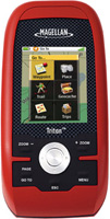 | Outdated Product $179.00 Pocket navigator for hiking and hiking. You can load the necessary maps of the area into the device; for this, the design provides a slot for SD memory cards, there is a route calculation function. Up to 20 routes can be stored in the device's memory. The body of the navigator has dust and water protection according to the IPX7 level. Powered by a set of two AA batteries, they last for 10 hours of continuous operation of the device. |
Magellan Triton 400
Type:handheld
Screen size:2.2 "
Resolution:320х240 px
Working hours:up to 10 h
Weight:187 g
Pocket navigator for hiking and hiking. You can load the necessary maps of the area into the device; for this, the design provides a slot for SD memory cards, there is a route calculation function. Up to 20 routes can be stored in the device's memory. The body of the navigator has dust and water protection according to the IPX7 level. Powered by a set of two AA batteries, they last for 10 hours of continuous operation of the device.
All specifications
Specifications Triton 400
|
| |||||||||||||||||||||||||||||||||||||||||||||||||||||||||||
The information in the model description is for reference purposes.
Always clarify the specifications and configuration of the product with the online store manager before purchasing.
Catalog Magellan 2025 - new arrivals, bestsellers, and the most relevant models Magellan.
Always clarify the specifications and configuration of the product with the online store manager before purchasing.
Catalog Magellan 2025 - new arrivals, bestsellers, and the most relevant models Magellan.
Additional features sat nav Magellan Triton 400:
WAAS (Wide Area Augmentation System) is a system designed to increase the accuracy of satellite navigation instruments. The principle of operation of the system is based on the correction of satellite data with the help of special corrections, which are calculated by base stations installed in the service area of the system.
- WAAS technology
- Accuracy: less than 7 metres, when using WAAS — less than 3 metres
- Update rate — 1 time / sec
- Built-in compass
- Operating temperature -10° to +60°C
WAAS (Wide Area Augmentation System) is a system designed to increase the accuracy of satellite navigation instruments. The principle of operation of the system is based on the correction of satellite data with the help of special corrections, which are calculated by base stations installed in the service area of the system.


