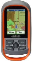
Magellan eXplorist 310
 | Outdated Product Pocket GPS receiver for extreme hikes. The IPX7 dust-proof housing will withstand any weather conditions. A set of 2 AA batteries will last for 18 hours of using the gadget. Built-in permanent memory of 2GB by 1.5GB is filled with a pre-installed base card. Additional maps can be loaded using the USB interface. The device supports geocaching, can remember up to 50 routes and put down up to 100 waypoints. E-Catalog uses affiliate links compensated by our partners. |
We recommend products in stockSat Navs Magellan →
handheld, 2.2 ", memory 8 GB, water protection IPX7, non chargeable batteries, up to 25 hours of work, 142 g
handheld, 2.6 ", water protection IPX7, non chargeable batteries, up to 18 hours of work, 203 g
handheld, 2.2 ", memory 3.7 GB, water protection IPX7, non chargeable batteries, up to 25 hours of work, 142 g
handheld, 2.2 ", water protection IPX7, non chargeable batteries, up to 168 hours of work, 157 g
handheld, 2.6 ", water protection IPX7, non chargeable batteries, up to 20 hours of work, 260 g
wrist-mounted, 2.2 ", ANT+, water protection IPX7, non chargeable batteries, up to 100 hours of work, 108 g
handheld, 2.2 ", memory 8 GB, ANT+, water protection IPX7, non chargeable batteries, up to 25 hours of work, 142 g
handheld, 2.2 ", water protection IPX7, non chargeable batteries, up to 25 hours of work, 142 g
handheld, 3 ", memory 8 GB, water protection IPX7, non chargeable batteries, up to 19 hours of work, 282 g
handheld, 2.6 ", memory 16 GB, ANT+, water protection IPX7, non chargeable batteries, up to 16 hours of work, 217 g
handheld, 2.6 ", memory 16 GB, ANT+, water protection IPX7, non chargeable batteries, up to 16 hours of work, 217 g
handheld, 3 ", memory 16 GB, Wi-Fi, ANT+, water protection IPX7, up to 180 hours of work, 230 g
handheld, 3 ", memory 4 GB, Wi-Fi, ANT+, water protection IPX7, up to 18 hours of work, 272 g
Magellan eXplorist 310
Type:handheld
Screen size:2.2 "
Resolution:320х240 px
Power supply:non chargeable battery
Working hours:up to 18 h
Weight:147 g
Pocket GPS receiver for extreme hikes. The IPX7 dust-proof housing will withstand any weather conditions. A set of 2 AA batteries will last for 18 hours of using the gadget. Built-in permanent memory of 2GB by 1.5GB is filled with a pre-installed base card. Additional maps can be loaded using the USB interface. The device supports geocaching, can remember up to 50 routes and put down up to 100 waypoints.
All specifications
Specifications eXplorist 310
|
| |||||||||||||||||||||||||||||||||||||||||||||||||||||||||
The information in the model description is for reference purposes.
Always clarify the specifications and configuration of the product with the online store manager before purchasing.
Catalog Magellan 2026 - new arrivals, bestsellers, and the most relevant models Magellan.
Always clarify the specifications and configuration of the product with the online store manager before purchasing.
Catalog Magellan 2026 - new arrivals, bestsellers, and the most relevant models Magellan.
Additional features sat nav Magellan eXplorist 310:
WAAS technology
WAAS (Wide Area Augmentation System) is a system designed to increase the accuracy of satellite navigation instruments. The principle of operation of the system is based on the correction of satellite data with the help of special corrections, which are calculated by base stations installed in the service area of the system.
- WAAS technology
- Recording of route data: average speed, distance, travel and halt times, altitude, etc.
- Geocaching support
WAAS technology
WAAS (Wide Area Augmentation System) is a system designed to increase the accuracy of satellite navigation instruments. The principle of operation of the system is based on the correction of satellite data with the help of special corrections, which are calculated by base stations installed in the service area of the system.